2017 / S13 D14
- Start: 🇫🇷 FR-48 Florac Trois Rivières
- Finish: 🇫🇷 FR-48 Le Rozier
- Date: Thursday 15 June 2017
- Night: Grand Hôtel des Voyageurs
- Departure and arrival times: 10h18 − 19h53
- Counter/pause time (total): 4h14 / 5h21 (9h35)
- Number of kilometers: 67,400 km
- Average speed (max): 15,9 km/h (39,1 km/h)
- Total number of kilometers: 836,3 » 903,7 km / 1085,4 km
- GPX file: download /
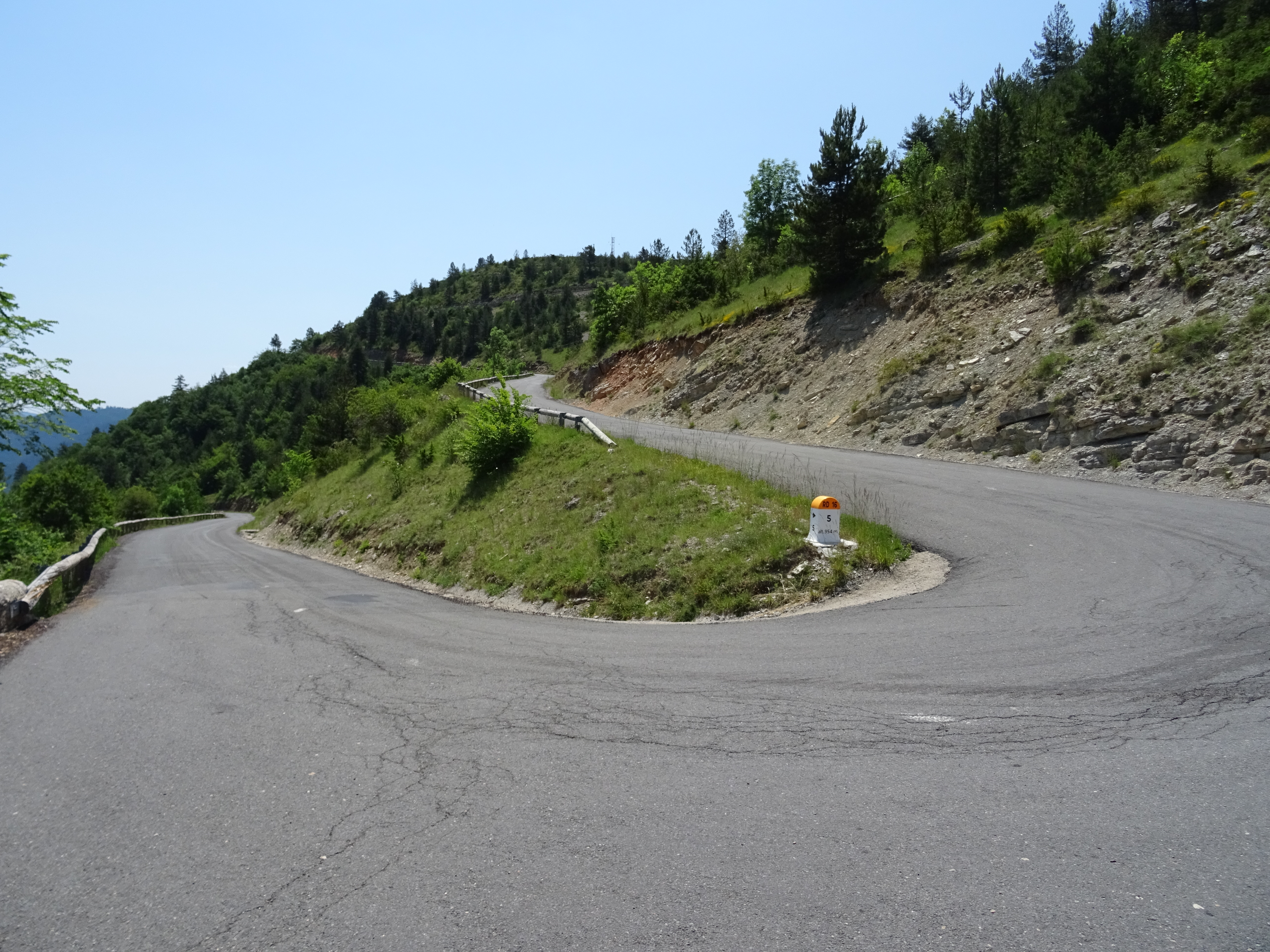
- Col de Pierre Plate, 1016 m (go to)
15/06/2017

- FR-48 Florac Trois Rivières
- 605340.jpg / download
- date: 2017-06-15 10:40:40 +02:00
- latitude: 44.324309
- longitude: 3.588021
- altitude: ~ 614 m

- FR-48 Florac Trois Rivières
- 605343.jpg / download
- date: 2017-06-15 12:09:00 +02:00
- latitude: 44.330617
- longitude: 3.575186
- altitude: ~ 800 m

- FR-48 Florac Trois Rivières
- 605344.jpg / download
- date: 2017-06-15 12:52:05 +02:00
- latitude: 44.332801
- longitude: 3.568129
- altitude: ~ 956 m

- FR-48 Florac Trois Rivières
- 605345.jpg / download
- date: 2017-06-15 12:52:10 +02:00
- latitude: 44.332801
- longitude: 3.568129
- altitude: ~ 956 m

- FR-48 Florac Trois Rivières
- 605346.jpg / download
- date: 2017-06-15 13:07:30 +02:00
- latitude: 44.329597
- longitude: 3.571884
- altitude: ~ 963 m

- FR-48 Florac Trois Rivières
- 605347.jpg / download
- date: 2017-06-15 13:07:39 +02:00
- latitude: 44.329597
- longitude: 3.571884
- altitude: ~ 963 m

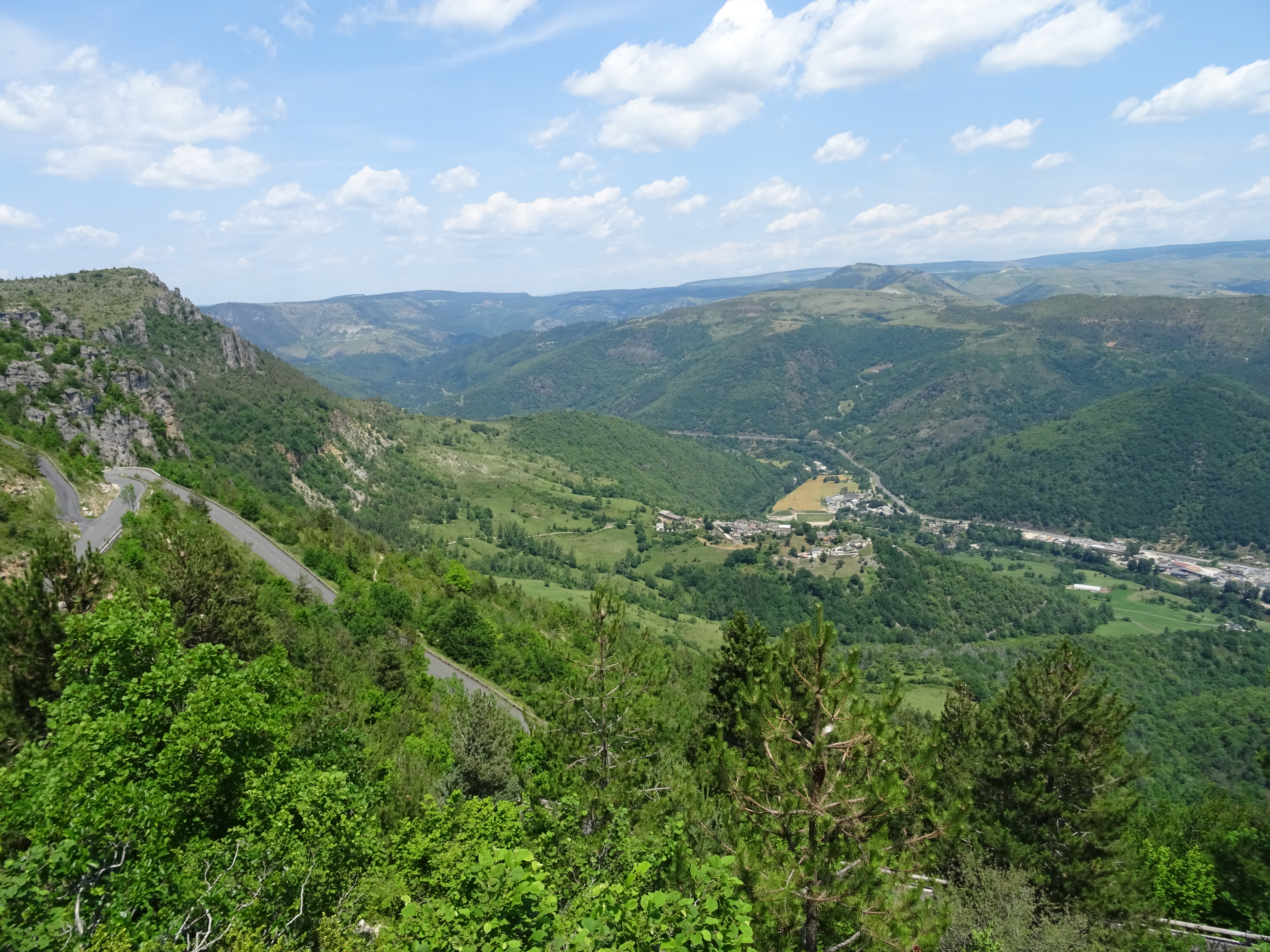
- FR-48 Florac Trois Rivières
- 605348.jpg / download
- date: 2017-06-15 13:10:05 +02:00
- latitude: 44.330211
- longitude: 3.570154
- altitude: ~ 1005 m

- FR-48 Florac Trois Rivières
- 605349.jpg / download
- date: 2017-06-15 13:21:46 +02:00
- latitude: 44.327493
- longitude: 3.571536
- altitude: ~ 1058 m

- FR-48 Florac Trois Rivières
- 605350.jpg / download
- date: 2017-06-15 13:23:49 +02:00
- latitude: 44.327181
- longitude: 3.571875
- altitude: ~ 1051 m

- FR-48 Florac Trois Rivières
- 605351.jpg / download
- date: 2017-06-15 13:23:53 +02:00
- latitude: 44.327181
- longitude: 3.571875
- altitude: ~ 1051 m

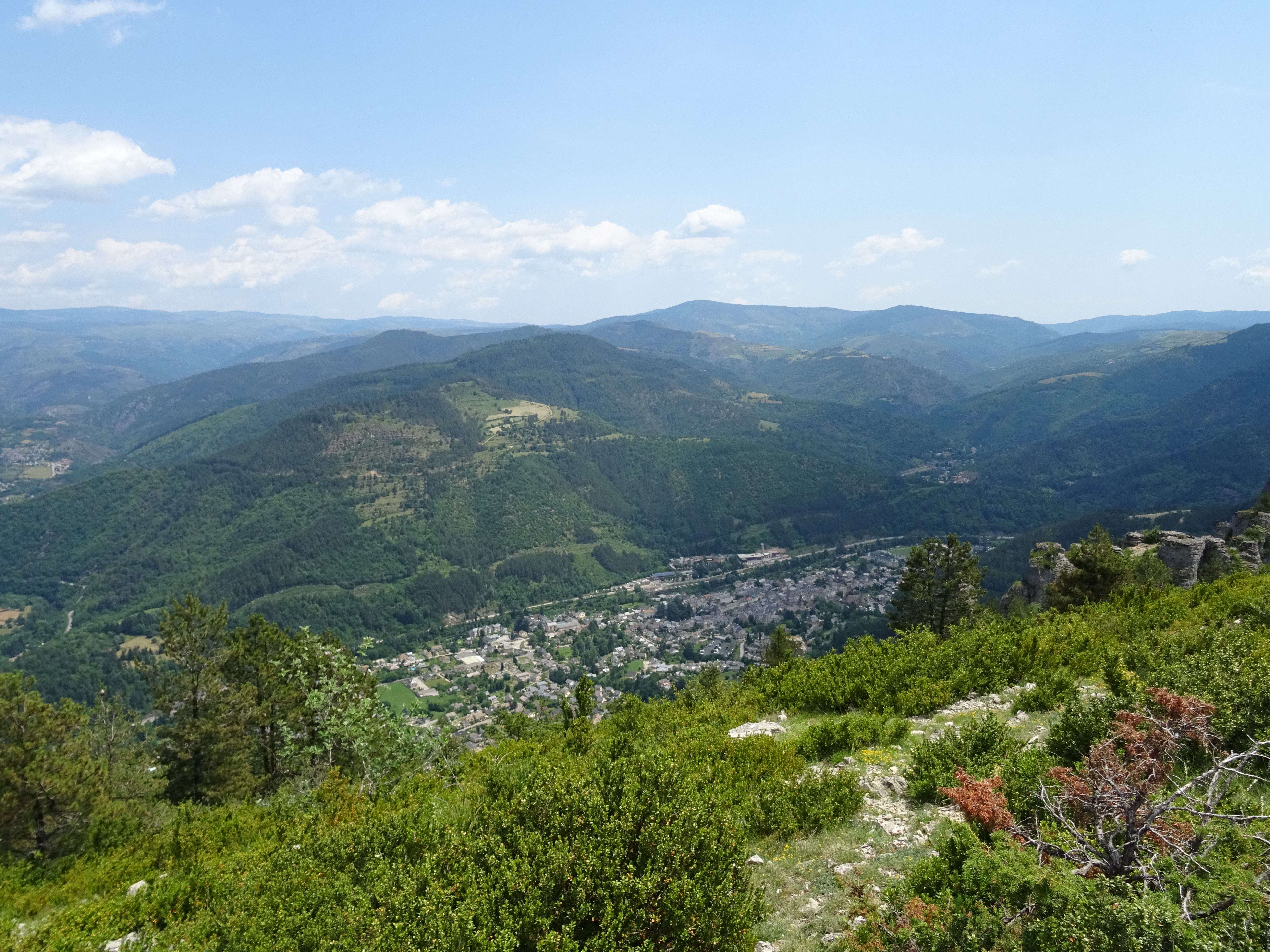
- FR-48 Florac Trois Rivières
- 605353.jpg / download
- date: 2017-06-15 13:33:10 +02:00
- latitude: 44.327538
- longitude: 3.570996
- altitude: ~ 1057 m

- FR-48 Florac Trois Rivières
- 605354.jpg / download
- date: 2017-06-15 13:40:59 +02:00
- latitude: 44.331189
- longitude: 3.565190
- altitude: ~ 1041 m

- FR-48 Florac Trois Rivières
- 605355.jpg / download
- date: 2017-06-15 13:41:04 +02:00
- latitude: 44.331235
- longitude: 3.565170
- altitude: ~ 1041 m

- FR-48 Florac Trois Rivières
- 605356.jpg / download
- date: 2017-06-15 13:41:09 +02:00
- latitude: 44.331235
- longitude: 3.565170
- altitude: ~ 1041 m

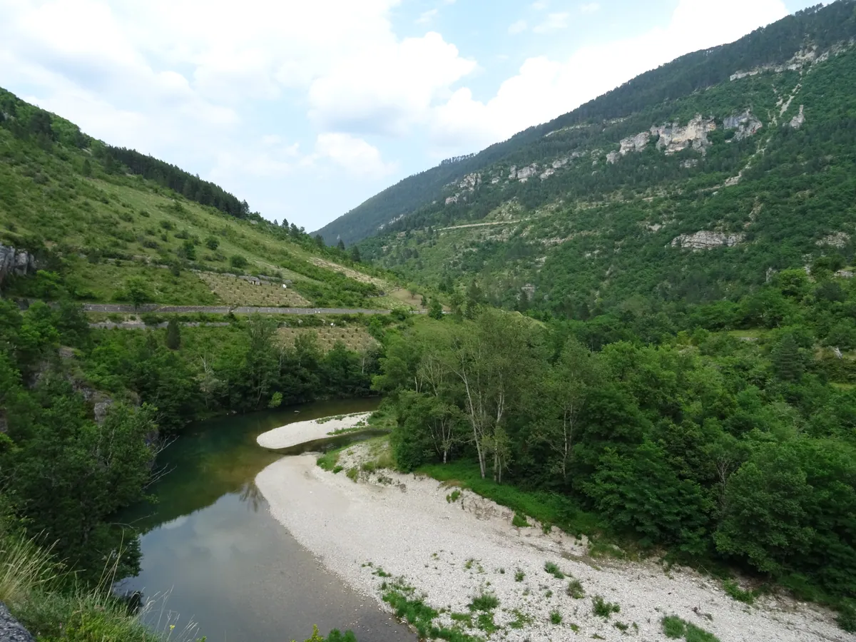
- FR-48 Gorges du Tarn
- 605357.jpg / download
- date: 2017-06-15 14:11:28 +02:00
- latitude: 44.335811
- longitude: 3.510145
- altitude: ~ 746 m

- FR-48 Gorges du Tarn
- 605359.jpg / download
- date: 2017-06-15 14:12:04 +02:00
- latitude: 44.335811
- longitude: 3.510145
- altitude: ~ 746 m

- FR-48 Gorges du Tarn
- 605360.jpg / download
- date: 2017-06-15 14:19:07 +02:00
- latitude: 44.336126
- longitude: 3.505234
- altitude: ~ 607 m

- FR-48 Gorges du Tarn
- 605361.jpg / download
- date: 2017-06-15 14:53:42 +02:00
- latitude: 44.341804
- longitude: 3.466377
- altitude: ~ 558 m

- FR-48 Gorges du Tarn
- 605362.jpg / download
- date: 2017-06-15 14:55:35 +02:00
- latitude: 44.342984
- longitude: 3.466066
- altitude: ~ 577 m

- FR-48 Gorges du Tarn
- 605363.jpg / download
- date: 2017-06-15 16:30:00 +02:00
- latitude: 44.363694
- longitude: 3.409746
- altitude: ~ 498 m

- FR-48 Gorges du Tarn
- 605364.jpg / download
- date: 2017-06-15 17:09:03 +02:00
- latitude: 44.344154
- longitude: 3.389070
- altitude: ~ 451 m
- FR-48 Gorges du Tarn
- 605367.jpg / download
- date: 2017-06-15 17:33:43 +02:00
- latitude: 44.337992
- longitude: 3.361162
- altitude: ~ 500 m

- FR-48 Gorges du Tarn
- 605368.jpg / download
- date: 2017-06-15 18:09:11 +02:00
- latitude: 44.302908
- longitude: 3.295915
- altitude: ~ 432 m

- FR-48 Gorges du Tarn
- 605369.jpg / download
- date: 2017-06-15 18:23:48 +02:00
- latitude: 44.297828
- longitude: 3.281428
- altitude: ~ 454 m

- FR-48 Gorges du Tarn
- 605370.jpg / download
- date: 2017-06-15 18:32:48 +02:00
- latitude: 44.305280
- longitude: 3.265480
- altitude: ~ 436 m

- FR-48 Gorges du Tarn
- 605371.jpg / download
- date: 2017-06-15 18:58:27 +02:00
- latitude: 44.290393
- longitude: 3.238142
- altitude: ~ 443 m

- FR-48 Gorges du Tarn
- 605372.jpg / download
- date: 2017-06-15 18:58:48 +02:00
- latitude: 44.290349
- longitude: 3.238118
- altitude: ~ 443 m

- FR-48 Gorges du Tarn
- 605373.jpg / download
- date: 2017-06-15 18:59:02 +02:00
- latitude: 44.290349
- longitude: 3.238118
- altitude: ~ 443 m

Toutes les heures sont en heure locale, et malheureusement soit en heure d'été, soit en heure d'hiver. Pour tous les voyages : utc+1 en hiver et utc+2 en été, sauf Finlande/Estonie/Lettonie/Lituanie utc+2/+3.
Blog de voyages à vélo
Les photos et vidéos et podcasts sont sous licence Creative Commons BY-NC-SA 3 (Attribution - Pas d'utilisation commerciale - Partage dans les mêmes conditions).
Exceptions (extrait musical/audio) :
- 2023.7.m4a, © Aden Foyer The Ballet Girl
- 2023.16.m4a, © Voyager Promise, © WarnerBros Matrix 4
- 608562.jpg, © Foto-Webcam.eu
Index des photos : TSV.
Historique des voyages à vélo
- la suite ?
- 2024-2025 / 352 jours ~ 12 mois (14580 € soit 36/j) / bivouac tente
(16 pays, 2 îles)- VTC 28″ VSF T-500, 11-36, pneu marathon plus tour, usb-werk
- TEL Wiko Power U10° et realme C53° (GPS OsmAnd, cartes OSM/OTM)
- APN Sony DSC-HX60V°
- CAM GoPro Hero 10° avec module média
- Drone DJI Mini 3 pro°
- 2023 / 90 jours, 3 mois (8103 € soit 90/j)
🇫🇷 FR 🇨🇭 CH 🇦🇹 AT 🇨🇭 CH 🇮🇹 IT 🇫🇷 FR (4 pays)- VTC 28″ VSF T-500, 11-36, pneu marathon plus tour, usb-werk
- TEL Wiko Power U10° (GPS OsmAnd, cartes OSM/OTM)
- APN Sony DSC-HX60V°
- CAM GoPro Hero 10° avec module média
- Drone DJI Mini 3 pro°
- 2019 / 🇫🇷 FR / 25 jours (2753 € soit 110/j)
- VTT 27,5″ Rockrider 520, 13-32, roue avant XM-319 DH-3D32, usb-werk
- GPS TwoNav Anima (cartes IGN TOP25)
- APN Sony DSC-HX60V°
- 2018 / 🇫🇷 FR / 17 jours (1435 € soit 84/j)
- VTT 26″ Rockrider 5.1 C1 2011, 13-34
- GPS TwoNav Anima (cartes IGN TOP25)
- APN Sony DSC-HX60V°
- 2017 / 🇫🇷 FR / 17 jours (1480 € soit 87/j)
- VTT 26″ Rockrider 5.1 C1 2011, 13-34
- GPS TwoNav Anima (cartes IGN TOP25)
- APN Sony DSC-HX60V°
- 2014 / 🇫🇷 FR / 10 jours (1018 € soit 101/j)
- VTT 26″ Rockrider 5.1 C1 2011, 13-34
- GPS TwoNav Sportiva 2 (cartes IGN TOP25)
- APN Canon PowerShot SX280HS°
- 2013 / 🇫🇷 FR / 15 jours
- VTT 26″ Rockrider 5.1 C1 2011
- GPS TwoNav Sportiva 2 (cartes IGN TOP25)
- APN Canon IXUS 220HS
- 2012 / 🇫🇷 FR / 12 jours / camping tente
- VTT 26″ Rockrider 5.1 C1 2011
- GPS IGN Évadéo M35 (cartes IGN TOP25)
- APN Canon IXUS 220HS
- 2009 / 🇫🇷 FR / 16 jours / camping tente
- VTT 26″
- GPS IGN Évadéo M35 (cartes IGN TOP25)
- APN Canon PowerShot A430
Rendez-vous aussi sur
- VisuGPX / EditGPX (éditeur d'itinéraire un peu bancale)
- SchweizMobil (carte interactive avec itinéraires et photos)
- Foto-Webcam (webcams avec historique - AT-Schröcken 13/08/23)
- Trustroots (hébergement entre voyageurs)
- Nomador (home-sitters... miaou)
- uBlock (pour votre santé)
- trop d'argent ? pas de soucis je m'en occupe
Des histoires d'autres voyageurs
- Perdons les pédales
- La Bliv America
- Voies Recyclables
- ZedZed Bizarre Adventure
- Charles en vélo
- Un petit tour à vélo
- Nartrouv Travel
- flo_madem
- Les Cyclotrotters
- À Vélo A. A. A.
- À coups de pédales
- What The Trip
- Les Colibris nomades
- Cycle Americas
- La Pampa (audio)
- From Cape to Cairo by Bike (film)
- Génération Tour du Monde (film)
- Vanlife les nouveaux nomades (film)
- Ameri-Bike Dream (film)
- Un Tour d'Europe en 11 mois (film)
- Cycling Across Europe Alone (film)
- Lampaul/CapNord à vélo (film)
- Jencyo Rêva
Quelques informations pas très intéressantes
Les communes des photos ont été récupérées avec Google Geocoding puis Nomitim Reverse et les altitudes avec elevation-api.eu (mais par moment c'est très approximatif), le tout à partir de leurs coordonnées GPS. Les tuiles (tiles) des itinéraires ont été générées avec gpx2tiles. Page web réalisée avec tout mon talent en France, mais aussi grâce à Leaflet, Leaflet.RightClickZoom, Leaflet.Fullscreen et Leaflet.GPX.
Les coordonnées des photos de 2009, 2012 et 2013 ont été ajoutées manuellement. Une * indique un positionnement (très) approximatif. Les itinéraires de 2009 et 2012 ont été retracés quelques années après.
Itinéraires préparés avec VisuGPX et SuisseMobile.
Attention, quand EDF passe, le paysage trépasse !
Et Android ? Même Windows XP était mieux !
Loués soient les Oris !
Nous sommes sponsorisés par la région.